
Water Quality of physiographic Region of Nepal
What Nepal's water quality data tells the forestry sector
I spent the last few weeks pulling together every published water quality study I could find for Nepal and rearranging the results by physiographic region instead of by river basin or province. This post is about something that came out of the work sideways, which is how much of that data belongs in forestry planning and how little of it we currently use there.
Why the data is hard to use as it stands
Water quality in Nepal gets reported in units that do not match the way we classify land. Researchers report by river basin. Household surveys report by province and by urban or rural. Forestry, soil and land use statistics run on the LRMP physiographic classification: High Himal, High Mountain, Middle Mountain, Siwalik and Terai. None of these line up, so a division forest officer who wants to know whether the water leaving a managed catchment is getting better or worse has no easy way to find out.
Rearranging the published record by physiographic region took some effort, but it made the pattern obvious in a way the basin-level literature does not.
What the record actually shows
Dissolved solids climb steadily as you come down the country, from 13 to 39 mg/L in the Everest headwaters to 106 to 252 mg/L in the Terai reach of the Tinau. That is weathering first and land use second, and it is a normal, expected gradient.
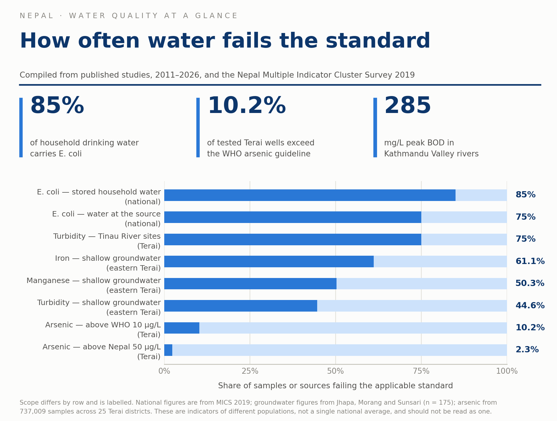
Microbial contamination does not follow that gradient at all. It tracks settlement density and sanitation. Nationally, 75 per cent of source water and 85 per cent of stored household water tested positive for E. coli in the 2019 Multiple Indicator Cluster Survey. The same problem shows up at 4,000 metres in Khumbu lodges and at 100 metres in Terai towns.
Three region-specific findings stood out:
- Siwalik. Turbidity and suspended sediment, not dissolved chemistry, are the governing variables. The Ratuwa study found turbidity of 2 to 11 NTU and a clear decline from upstream to downstream. The Chure is young, weakly consolidated and erodable, and the water shows it.
- Middle Mountain. Two completely different pictures in one belt. Rural springs pass on chemistry but fail on E. coli. Kathmandu Valley rivers run at BOD of 76.8 to 285 mg/L with dissolved oxygen down to 1.02 mg/L, which is sewage-strength water.
- Terai. Arsenic affects 7.9 per cent of tested wells at 10 to 50 µg/L and 2.3 per cent above 50 µg/L. But in the eastern Terai, iron failed the national standard in 61.1 per cent of samples and manganese in 50.3 per cent, far more wells than arsenic did.
Where forestry comes in
Six uses, in rough order of how ready they are.
- Chure conservation gets a measurable outcome indicator. We spend a lot on Chure plantation and soil conservation and report it in hectares planted and structures built. Those are inputs. Turbidity and suspended sediment in streams leaving a treated catchment are outputs, and they respond to forest cover on a timescale short enough to show up in a programme cycle. If we set up a small number of Chure monitoring transects with turbidity as the primary variable, we would be able to say whether the money is working. Right now we cannot.
- Springshed management gains a targeting rule. Springs supply most midland settlements. The Tanahun study measured three springs a short distance apart and found water quality index values of 15.76, 38.65 and 61.08. Adjacent springs were nothing like each other. That means recharge area condition, which is largely a forest and land cover question, matters more than regional averages. It also means you cannot plan spring protection off a district figure. Each recharge area has to be assessed on its own.
- Community forest operational plans can carry a water clause. Most operational plans already mention watershed protection as a management objective and then never measure it. Adding two simple readings at the nearest downstream source, turbidity and a coliform presence test, taken three times a year, would give user groups something concrete to manage toward. It would also give us the first large dataset on what community forestry does to water, which nobody in Nepal currently has.
- Riparian and buffer planting has a target it can be sized against. Both the Ratuwa and the Tinau show quality declining steadily as rivers pass through settled areas. That downstream decline is precisely what buffer strips act on. With before-and-after readings at the same points, buffer width and species choice become design decisions with evidence behind them rather than convention.
- Ecosystem accounting needs water quality as a condition variable. Under the SEEA framework, each forest ecosystem unit is assigned a condition class. Water quality is one of the variables that determines that class, alongside vegetation, biodiversity and soil. Without regional water quality data the condition assessment is built on the other variables alone, and the resulting account understates what forests do.
- Any payment for the watershed services scheme needs a baseline first. Downstream users will not pay for upstream forest management unless the service can be measured, and the measurement has to predate the payment. Every hydropower catchment or municipal water scheme where such an arrangement might be set up needs a water quality baseline established now, before any negotiation starts.
What forestry cannot fix, and why saying so matters
Forestry can act on turbidity, suspended sediment, nutrient runoff and the organic load that comes with land clearance. It has no effect on arsenic, iron or manganese in Terai groundwater. Those are geogenic, sitting in the aquifer sediments, and no amount of plantation changes them. Forestry also does nothing about the ten-percentage-point gap between contamination at the source and contamination in the household storage pot, which is a handling and treatment problem.
This distinction is worth stating clearly in any forestry document that cites water quality data. If we claim more than the sector can deliver, the first evaluation that tests the claim will damage the credibility of the things forestry genuinely does affect.
The gap I could not close
Of 140 published water quality studies reviewed nationally, 76 come from Bagmati Province. Karnali, Madhesh and Sudurpaschim have one or two each. The Siwalik, which is the recharge zone for Terai aquifers and a declared conservation priority, has almost no dedicated record at all. Its water quality is known only indirectly, from rivers sampled after they have already left it.
That is a strange gap for a country that has made Chure conservation a national programme. Division forest offices are already in those catchments every month. Adding a turbidity meter and a coliform test kit to the existing field routine would cost very little and would close a hole that no amount of desk review can.(https://drive.google.com/file/d/1kMBUXOIrEScmUbfuizRfyxh9ISFkApJS/view?usp=drive_link)